28 Nov 2012 AGFC unveils new locator service for smartphones
The Arkansas Game and Fish Commission has released a new locator service for smartphones.
It uses Geographic Information Systems data, but it doesn’t produce a map typically associated with GIS data. Instead, it simply displays the information for your location.
According to AGFC Geographic Information Systems Coordinator Tracy Moy, the service was developed as a result of another GIS project. “After seeing the value of the service, we determined it would be helpful to others and made a few alterations to it to make it usable for public consumption,” Moy said. “This is just another example of the power of GIS when data is properly placed into a geospatial system.”
The service will work anywhere in the world, but most data is specific for Arkansas, since it is using the AGFC or Arkansas GeoStor services to populate information like hunting zones or parcels. GeoStor is Arkansas’s public spatial data clearinghouse hosted by the Arkansas Geographic Information System Office.
Here’s how it works:
First, your smartphone’s GPS service must be enabled.
Access the service by opening your smartphone web browser and going to http://gis.agfc.com/locator.
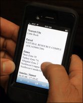
When the page loads, you can enter a specific latitude or longitude, or just click the “Locate Me” button. After clicking the button, the service will begin to initialize and will count down. It checks your current location, and after a few iterations, it locks on to a coordinate, a quick process that ensures an accurate reading. When the location is determined, it performs a spatial query by sending a message to the AGFC’s GIS services. The service is asking the GIS database to return information for your location. The results show location, county, township, range and section, as well as nearest city, sunrise and sunset for your specific location, hunting zone.
If available, it also displays the address and parcel information for your location. Several of the informational items are retrieved from other GIS databases that are not maintained by the AGFC. Since some of the informational items like parcel data are retrieved from GeoStor; and not all counties are complete, it may not be available for some locations.
The service can be added to the iPhone as a web app on your homepage.
If you want to see a map, the AGFC Mapper is also functional on a smartphone. You can visit that service at http://gis.agfc.com.
(Information provided by the Arkansas Game and Fish Commission.)


